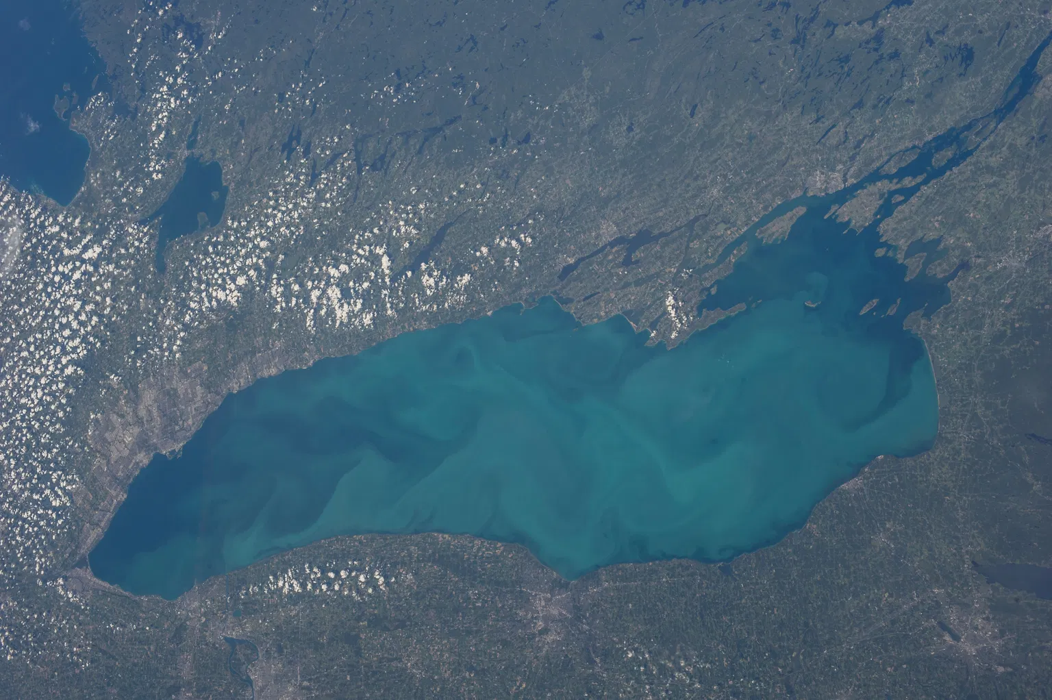
Lake Ontario — the easternmost and, by surface area, the smallest of North America's five Great Lakes — is now at the center of a cross-border naming dispute. On August 27, 2026, President Donald Trump signed an executive order renaming the lake "Lake America" and directing the U.S. Interior Department to update the federal Geographic Names Information System. Canada, which shares the lake with the United States, has rejected the change outright. Beyond the politics, Lake Ontario is a remarkable natural feature with a glacial origin story stretching back to the last ice age. Here is a factual guide to where the lake is, how it was formed, what makes it unique, and what the new name actually means in practice.
Where Lake Ontario Sits — and Why It's a "Great" Lake
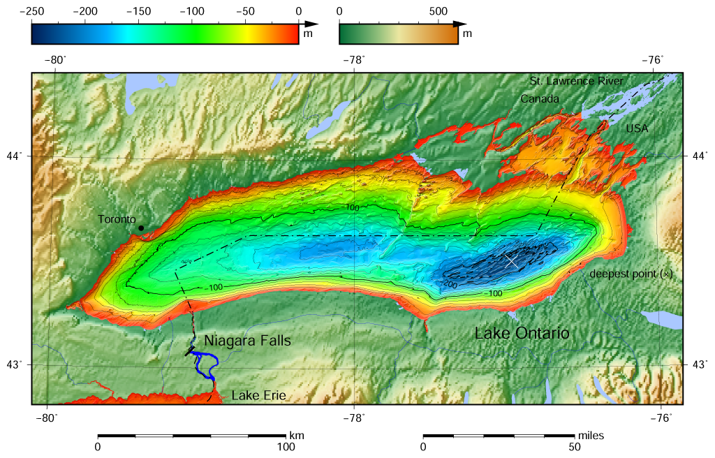
Lake Ontario is bordered on the north, west, and southwest by the Canadian province of Ontario, and on the south and east by the U.S. state of New York, with the international border running through the middle of the lake. It is the final lake in the Great Lakes chain: water flows into it from Lake Erie through the Niagara River, and out of it to the Atlantic Ocean via the St. Lawrence River and the St. Lawrence Seaway.
Though it is the smallest of the Great Lakes by surface area, the lake is far from shallow. According to the U.S. Environmental Protection Agency, the key measurements are:
- Surface area: 7,340 square miles (19,000 square kilometers)
- Length and width: 193 miles (311 km) long and 53 miles (85 km) wide at its widest point
- Average depth: 283 feet (86 meters)
- Maximum depth: 802 feet (244 meters), in the Rochester Basin
- Water volume: roughly 391 cubic miles (1,631 cubic kilometers) — the second-smallest of the Great Lakes
- Surface elevation: 243 feet (74 meters) above sea level
- Retention time: about 6 years, the time it takes for the lake's water to be fully replaced
The name "Ontario" has Indigenous origins. It comes from Ontarí:io, a Wyandot (Huron) word meaning "great lake." Major cities on its shores include Toronto, Hamilton, Mississauga, Kingston, and St. Catharines on the Canadian side, and Rochester and Watertown on the American side.
How Lake Ontario Was Formed: From Ice Sheet to Inland Sea
Like the other Great Lakes, Lake Ontario owes its existence to the glaciers of the last ice age. The basin was carved out of relatively soft Silurian-age bedrock by the Wisconsin ice sheet, which scoured the region along a pre-glacial river valley that followed roughly the same orientation as today's lake. As the ice advanced and retreated, it pushed enormous amounts of sediment southward, leaving behind landforms such as drumlins, kames, and moraines that remain visible on the modern land surface and on the lake bottom.
During one stage of the ice retreat, the glacier still dammed the St. Lawrence Valley outlet, forcing the water to sit at a much higher level. Geologists call this ancient, larger version of the lake "Lake Iroquois." At that time, the lake drained not through the St. Lawrence but southwest through present-day Syracuse, New York, into the Mohawk River and then the Hudson River toward the Atlantic.
When the ice finally pulled back from the St. Lawrence Valley, the outlet was actually below sea level, and for a time the lake became an arm of the Atlantic Ocean, connected to what scientists call the Champlain Sea. As the enormous weight of roughly 6,500 feet (2,000 meters) of ice was lifted from the land, the crust began to rebound — a process that continues today at about 12 inches (30 centimeters) per century in the St. Lawrence area. Because this region rebounded last, it is still rebounding fastest, meaning the lake bed is slowly tilting southward and gradually reshaping the shoreline.
From Lake Ontario to "Lake America": What the Order Actually Does
The name change began as a social media threat and became federal policy within days. Earlier in the week, President Trump posted on Truth Social that the United States was giving "serious consideration" to renaming the lake, sharing a map with the label "Lake Ontario" crossed out. On Thursday, August 27, he signed the executive order in the Oval Office. "We're going to be changing the name of Lake Ontario, effective immediately, to Lake America," he said.
The order directs Interior Secretary Doug Burgum to update the Geographic Names Information System (GNIS), the federal database used with the U.S. Board on Geographic Names to standardize place names for government use. The director of the U.S. Geological Survey later posted a letter confirming the change had been made and "will begin occurring in printed documents over the next several days." The EPA has already updated its Great Lakes pages, which now list the five lakes as "Superior, Michigan, Huron, Erie and America."
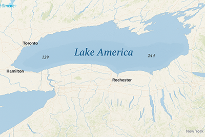
There is an important legal limit to the order: a U.S. president can control how the federal government labels the lake, but cannot force Canada, international bodies, or private companies to do the same. Canada has been unambiguous in its response. Prime Minister Mark Carney said the name "is more than 400 years old, predating both the Confederation of Canada and the Declaration of Independence," adding that "naming reality means calling it Lake Ontario — then, now and always." In New York, the only U.S. state that borders the lake, Gov. Kathy Hochul was blunt: "New York won't be calling it that."
Why the Lake Matters: Weather, Wildlife, and the Economy
Lake Ontario is more than a line on a map — it shapes the climate and economy of an entire region. Because of its depth, the lake rarely freezes over completely; a full ice cover has been recorded only five times, in 1830, 1874, 1893, 1912, and 1934. In winter, cold winds sweeping over the relatively warm water pick up moisture and drop it as heavy "lake-effect" snow, with the southern and southeastern shorelines forming a snowbelt where some areas between Oswego and Pulaski, New York, can receive 20 feet (600 cm) or more in a single season.
The lake's moderating effect also makes agriculture possible. Cool spring breezes delay fruit blooms until the danger of frost has passed, supporting commercial orchards of apples, cherries, pears, plums, and peaches around Rochester, as well as a major fruit-growing and wine-producing region on the Niagara Peninsula. The lake also anchors a freshwater fishery — though overfishing, pollution, and invasive species have stressed fish populations over the decades — and its coastal wetlands support a wide diversity of birds, fish, reptiles, amphibians, and plants.
What Happens Next for "Lake America"
The renaming is unfolding amid a deepening trade war between Washington and Ottawa, with 50% tariffs on some Canadian goods taking effect in recent days and further 50% tariffs on Canadian steel and auto imports announced for January. Canada has said it will impose matching tariffs of up to 50% on U.S. goods beginning September 8.
Practically speaking, federal maps, signs, and documents will shift to "Lake America," while Canadian and New York state materials will keep "Lake Ontario." The bigger question is how private mapmakers respond. After Trump renamed the Gulf of Mexico the "Gulf of America," some companies adopted the new name while others — including The Associated Press, which was later barred from some White House events — did not. MapQuest, Apple Maps, and Google Maps each had to decide then, and they will face the same choice now, which may explain why map-related searches have surged alongside the news. For his part, the president has already hinted at going further: "Now all we need is an ocean," he said, adding, "maybe we'll have to change the name of the Atlantic and — or — the Pacific."
Key Takeaways: Lake Ontario, Now "Lake America"
- Lake Ontario is the easternmost Great Lake and the smallest by surface area, though it is deeper than Lake Erie and holds about 391 cubic miles of water.
- It was carved by glaciers during the last ice age, passing through stages known as Lake Iroquois and the Champlain Sea before reaching its present form.
- Its name comes from the Wyandot word Ontarí:io, meaning "great lake."
- On August 27, 2026, President Trump signed an executive order renaming it "Lake America" in federal U.S. records.
- The order binds U.S. federal agencies but not Canada, which continues to call it Lake Ontario.