
A massive tornado outbreak struck Kankakee County, Illinois and neighboring Indiana on Tuesday, March 11, 2025, leaving a trail of destruction, claiming at least two lives, and damaging dozens of homes. The severe weather event, which included at least four suspected tornadoes, serves as a stark reminder of the raw power of these violent atmospheric phenomena. Understanding how tornadoes form, why they occur, and how to stay safe during such events is crucial for anyone living in tornado-prone regions.
The Kankakee Tornado Outbreak: What Happened
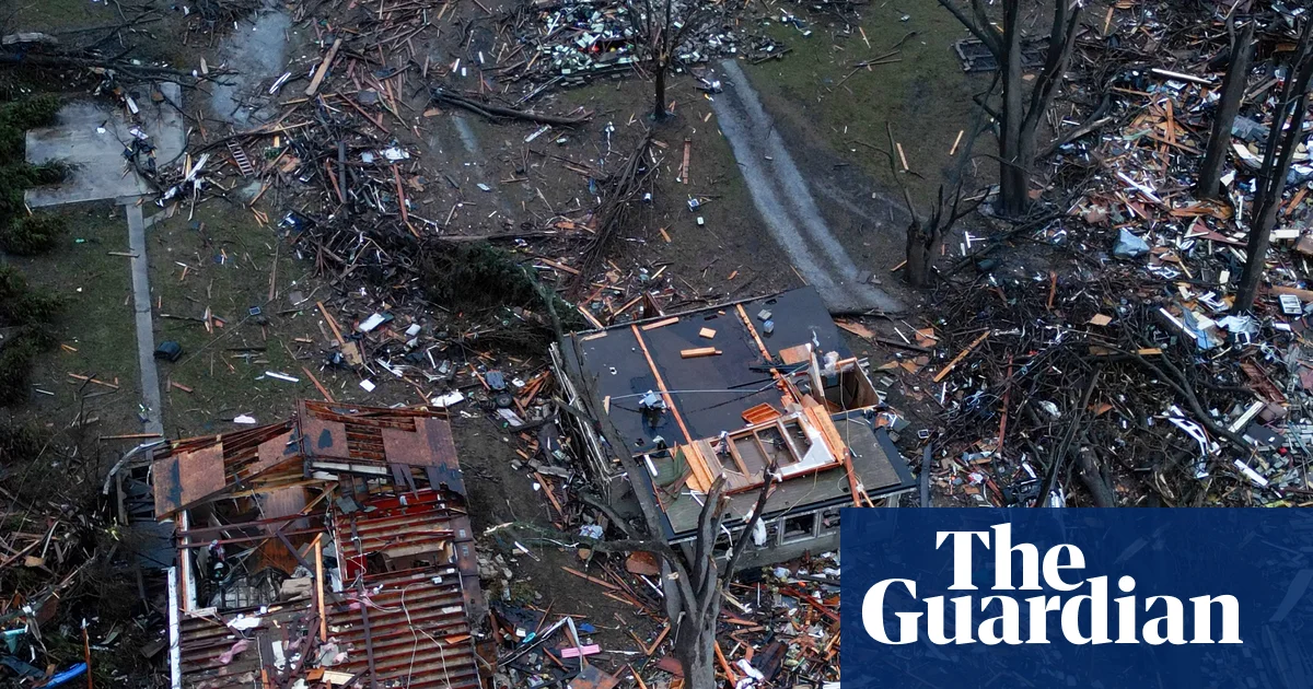
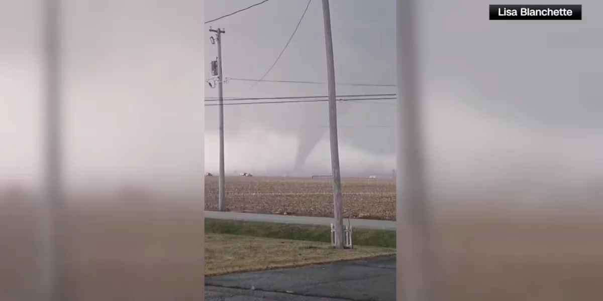
Emergency crews in Kankakee, Illinois, began assessing damage after a tornado touched down Tuesday afternoon amid an outbreak of severe weather. The National Weather Service reported a stovepipe tornado was spotted near the Kankakee Airport, moving toward Aroma Park, Illinois, and then on to Momence. A second tornado touchdown was confirmed at the Kankakee County Fairgrounds. CBS News Chicago meteorologist Kylee Miller, who was on the scene, reported significant damage including destroyed homes and downed power lines in the area where the touchdown occurred.
Confirmed tornadoes were also reported over parts of northwest Indiana, where emergency crews advised residents to stay put and avoid assessing damage themselves due to ongoing hazards. The severe weather barreled into downtown Chicago shortly before 6:30 p.m., with thunderstorms quickly giving way to a downpour and then an onslaught of hail. Large hail was reported in the southwest suburbs, with hail as large as 5.2 inches in Kankakee—potentially a record for Illinois, according to Meteorologist David Yeomans.
CBS News Chicago Chief Meteorologist Albert Ramon called this severe weather risk "as high as we've seen in several years," emphasizing the importance of having multiple ways to receive warnings and being ready to act quickly. In anticipation of the severe weather, the Manteno Police Department opened two storm shelters for residents without basements, highlighting the community's preparedness efforts.
What Exactly Is a Tornado?
According to the National Oceanic and Atmospheric Administration (NOAA), a tornado is a narrow, violently rotating column of air that extends from a thunderstorm to the ground. Because wind is invisible, tornadoes are often identified by the condensation funnel they create—a visible column made up of water droplets, dust, and debris. Tornadoes rank among the most violent phenomena of all atmospheric storms, capable of winds exceeding 300 miles per hour in the most extreme cases.
The United States experiences approximately 1,200 tornadoes each year, though official records only date back to 1950, making it difficult to determine precise historical averages. While "Tornado Alley"—a broad area of relatively high tornado occurrence in the central United States—receives significant attention, tornadoes can and do occur in all fifty states. The tornado threat shifts geographically with the seasons, moving from the Southeast in cooler months to the Plains in May and June, then to the northern Plains and Midwest during early summer.
The Science Behind Tornado Formation
Tornadoes don't form randomly; they require a specific combination of atmospheric ingredients coming together in just the right way. Meteorologists identify four key components necessary for tornado development: moisture, instability, lift, and wind shear.
Moisture provides the fuel for thunderstorms, typically coming from warm, humid air near the ground. Instability refers to the atmosphere's tendency to promote upward motion—when warm air near the surface is capped by cooler air above, it creates a situation where the warm air wants to rise rapidly. Lift is the mechanism that gets this upward motion started, often provided by frontal boundaries, dry lines, or outflow boundaries from other storms.
The most critical ingredient for tornado formation is wind shear—the change in wind speed and/or direction with height. When winds at different altitudes blow at different speeds or from different directions, they create horizontal rotation in the atmosphere. This horizontal rotation can be tilted vertically by thunderstorm updrafts, forming the rotating mesocyclone that can potentially spawn a tornado.
Step-by-Step: How a Tornado Develops
The process of tornado formation begins with the development of a supercell thunderstorm—a long-lived, rotating thunderstorm that maintains itself for hours. Within the supercell, a rotating updraft called a mesocyclone forms, typically 2-6 miles in diameter. As the storm intensifies, the mesocyclone tightens and extends downward toward the ground.
When the rotating column of air makes contact with the ground, it officially becomes a tornado. The visible funnel cloud forms as air pressure drops within the vortex, causing water vapor to condense. This condensation funnel may not always reach the ground, but if rotating debris is visible at the surface, the tornado is considered to be in contact regardless of whether the funnel is fully formed.
Tornadoes go through a life cycle that typically includes organizing, mature, and shrinking stages. The organizing stage sees the funnel descend from the cloud base, the mature stage features the tornado at its peak intensity and size, and the shrinking stage involves the vortex narrowing before dissipating. Most tornadoes last only a few minutes, but particularly violent ones can persist for over an hour and travel dozens of miles.
Types of Tornadoes and Their Characteristics
Tornadoes come in various forms, each with distinct characteristics. Rope tornadoes are narrow, sinuous, and often appear to be twisting or roping out as they dissipate. Stovepipe tornadoes have a cylindrical shape with relatively uniform width from cloud to ground—exactly the type reported in the Kankakee outbreak. Wedge tornadoes are wider than they are tall, sometimes exceeding a mile in width and appearing as a massive, dark block of destruction.
Tornado intensity is measured using the Enhanced Fujita (EF) Scale, which ranges from EF0 (65-85 mph winds, light damage) to EF5 (over 200 mph winds, incredible destruction). The scale considers damage indicators to estimate wind speeds, since directly measuring tornado winds is extremely challenging. Most tornadoes are relatively weak (EF0 or EF1), but the small percentage that reach EF4 or EF5 status account for the majority of tornado-related fatalities.
Tornado Safety: What to Do When a Warning Is Issued
Understanding tornado formation is important, but knowing how to stay safe is critical. The National Weather Service emphasizes the difference between a Tornado Watch and a Tornado Warning: a Watch means conditions are favorable for tornadoes to develop, while a Warning means a tornado has been sighted or indicated by radar and immediate action is required.
When a Tornado Warning is issued for your area, seek shelter immediately in a basement, storm cellar, or interior room on the lowest floor of a sturdy building. Avoid windows, and protect your head and neck with your arms or heavy blankets. If you're in a mobile home or vehicle, abandon it immediately for a substantial shelter. If no shelter is available, lie flat in a ditch or low-lying area and cover your head.
Having multiple ways to receive warnings—including NOAA Weather Radio, smartphone alerts, and local media—can provide crucial minutes of advance notice. Developing a family emergency plan and practicing tornado drills can make the difference between life and death when severe weather strikes.
The Kankakee Case Study: Why This Outbreak Happened
The March 11, 2025, outbreak in Kankakee County developed under classic tornado-forming conditions. A strong low-pressure system drew warm, moist air northward from the Gulf of Mexico, while a cold front approached from the west. This created the necessary instability as warm air rose through cooler air aloft. Wind shear was particularly pronounced, with winds at different altitudes blowing from different directions—creating the rotation necessary for tornado development.
The combination of these factors resulted in what meteorologists call a "moderate risk" day (level 4 out of 5 on the convective outlook scale), with the greatest tornado threat along and south of Interstate 80. The atmosphere was so unstable that it produced not only tornadoes but also record-breaking hail, with some stones reaching 5.2 inches in diameter—larger than a softball and potentially an Illinois state record.
This event illustrates how even areas not traditionally considered part of Tornado Alley can experience devastating tornado outbreaks when atmospheric conditions align. It also highlights the importance of heeding weather forecasts and warnings, as many residents in the affected areas had advance notice and were able to take shelter before the tornadoes struck.
The Future of Tornado Prediction and Safety
Meteorological advances continue to improve our ability to predict tornadoes and provide earlier warnings. Doppler radar technology can now detect rotation within thunderstorms before a tornado touches down, giving communities valuable extra minutes to seek shelter. The Warn-on-Forecast initiative aims to extend warning lead times even further by using high-resolution computer models to predict thunderstorm development hours in advance.
Community preparedness programs like StormReady and Weather-Ready Nation help municipalities develop comprehensive severe weather plans. Research initiatives like VORTEX (Verification of the Origins of Rotation in Tornadoes Experiment) continue to study tornado formation up close, using mobile radar units and instrumented vehicles to gather data that improves forecasting and understanding.
As climate patterns shift, scientists are studying how tornado frequency and distribution may change. While research continues, one thing remains clear: understanding tornado formation and knowing how to respond when warnings are issued will remain essential skills for anyone living in areas prone to severe weather.
Key Takeaways: Understanding Tornadoes
Tornadoes form when specific atmospheric conditions converge—warm moist air, instability, lift, and wind shear combine to create rotating thunderstorms that can produce violent columns of air. The recent Kankakee outbreak demonstrates how these ingredients can come together with devastating results, even in areas not traditionally associated with frequent tornado activity.
Knowing the difference between a Tornado Watch and Warning, having multiple ways to receive alerts, and practicing your emergency plan can save lives when severe weather strikes. While meteorologists continue to improve prediction capabilities, personal preparedness remains the most important factor in tornado safety.
By understanding the science behind these powerful storms, we can better appreciate the warning signs, respect the dangers, and take appropriate action when conditions warrant. The Kankakee tornado outbreak serves as both a tragedy and a teaching moment—reminding us of nature's power while highlighting the importance of scientific understanding and community preparedness in the face of severe weather.