Tropical Storm Rachel began as a late-season disturbance over the warm waters of the eastern Pacific Ocean, thousands of miles from the neighborhoods it would eventually flood. By the time its remnants reached Southern California in October 2026, Rachel had already peaked as a hurricane and weakened — yet its powerful surf still swamped streets on Newport Beach's Balboa Peninsula, destroyed beachfront homes in Long Beach, and triggered a tropical storm watch in San Diego for only the second time in the city's history. Rachel's story is a vivid case study in how tropical storms work: how they form, how they strengthen, and why even a weakened storm can unleash dangerous coastal flooding.
What Is a Tropical Storm? The Science Behind the Name
A tropical storm is a rotating, organized system of thunderstorms that forms over warm tropical or subtropical ocean water and produces sustained winds between 39 and 73 mph. It sits in the middle of a four-stage ladder that meteorologists use to classify tropical cyclones, the umbrella term for these spinning, ocean-born storms.
The weakest stage is a tropical disturbance, a cluster of thunderstorms with no organized circulation. When that cluster develops a closed circulation with sustained winds up to 38 mph, it becomes a tropical depression. If winds reach 39 mph, forecasters assign the system a name and it becomes a tropical storm. Once sustained winds hit 74 mph, the storm is upgraded to a hurricane (called a typhoon in the western Pacific or a cyclone in the Indian Ocean), and it climbs the five-category Saffir-Simpson scale — from Category 1 (74–95 mph) all the way up to Category 5 (157 mph or higher). Categories 3 and above are considered major hurricanes.
What sets a tropical storm apart from an ordinary thunderstorm is its structure and its energy source. A mature tropical cyclone has a calm, clear center called the eye, surrounded by a wall of the most intense thunderstorms, with spiral rain bands extending outward for hundreds of miles. The entire system is powered not by temperature contrasts — the way winter storms are — but by heat and moisture drawn from warm ocean water.
How Tropical Storms Form: Warm Water, Rising Air, and the Coriolis Effect
Tropical cyclones are, as NASA describes them, "giant engines that use warm, moist air as fuel." That is why they form only over warm ocean waters near the equator, where sea-surface temperatures reach at least 80 degrees Fahrenheit (about 26.5 degrees Celsius). The formation process unfolds in a predictable sequence.
First, warm, moist air rises from the ocean surface, leaving behind an area of low pressure. Surrounding air rushes in to fill that void, warms, and rises in turn. As this rising air cools high in the atmosphere, its water vapor condenses into towering clouds and releases latent heat — the energy that was stored when the water evaporated. That release of heat warms the air further, causing it to rise even more, and the cycle feeds on itself, building ever taller thunderstorms.
Second, Earth's rotation sets the growing system spinning. The Coriolis effect deflects moving air to the right in the Northern Hemisphere, giving the storm its characteristic counterclockwise rotation. This is also why tropical cyclones rarely form within about 5 degrees of the equator, where the Coriolis effect is too weak to organize the spin.
Finally, with a steady supply of warm water, low vertical wind shear (winds that change speed or direction with height and can rip a developing storm apart), and enough moisture, the system can organize into a tropical storm and intensify. Once a storm moves over cooler water or land — cutting off its warm-water fuel — it begins to weaken.
Tropical Storm Rachel: From Eastern Pacific Hurricane to a Historic California Threat
Rachel formed in late September 2026 in the eastern Pacific, where the hurricane season officially runs from May 15 through November 30. The eastern Pacific is one of the most active tropical cyclone basins on Earth, but most of its storms track west-northwest into the open ocean and die out harmlessly over cold water. Rachel took a different, more unusual path.
Early forecasts showed Rachel undergoing rapid intensification, a process in which a storm's maximum sustained winds increase by at least 35 mph in 24 hours. Forecasters expected Rachel to briefly become a major hurricane — a Category 3 storm with winds near 120 mph — before weakening. It did strengthen into a hurricane over the open Pacific, but as it curved northeast toward the Baja California Peninsula, it lost intensity over cooler waters and was downgraded to a tropical storm and then a post-tropical cyclone.
By October 10, 2026, the National Hurricane Center reported that Post-Tropical Cyclone Rachel had maximum sustained winds near 60 mph and was forecast to dissipate over the southwestern United States. Even in that weakened state, Rachel carried a threat that had little to do with its top wind speed: days of powerful surf, elevated tides, and a plume of tropical moisture aimed directly at the Southern California coast.
The storm's arrival triggered rare alerts. San Diego was placed under a tropical storm watch — only the second time in the city's history, after Hurricane Hilary in August 2023 — and much of Southern California, including Los Angeles and Las Vegas, was placed under a slight risk for excessive rainfall. Forecasters noted that Rachel could potentially become the first tropical storm to make landfall in Southern California in nearly a century.
Why Rachel Flooded Newport Beach and Long Beach
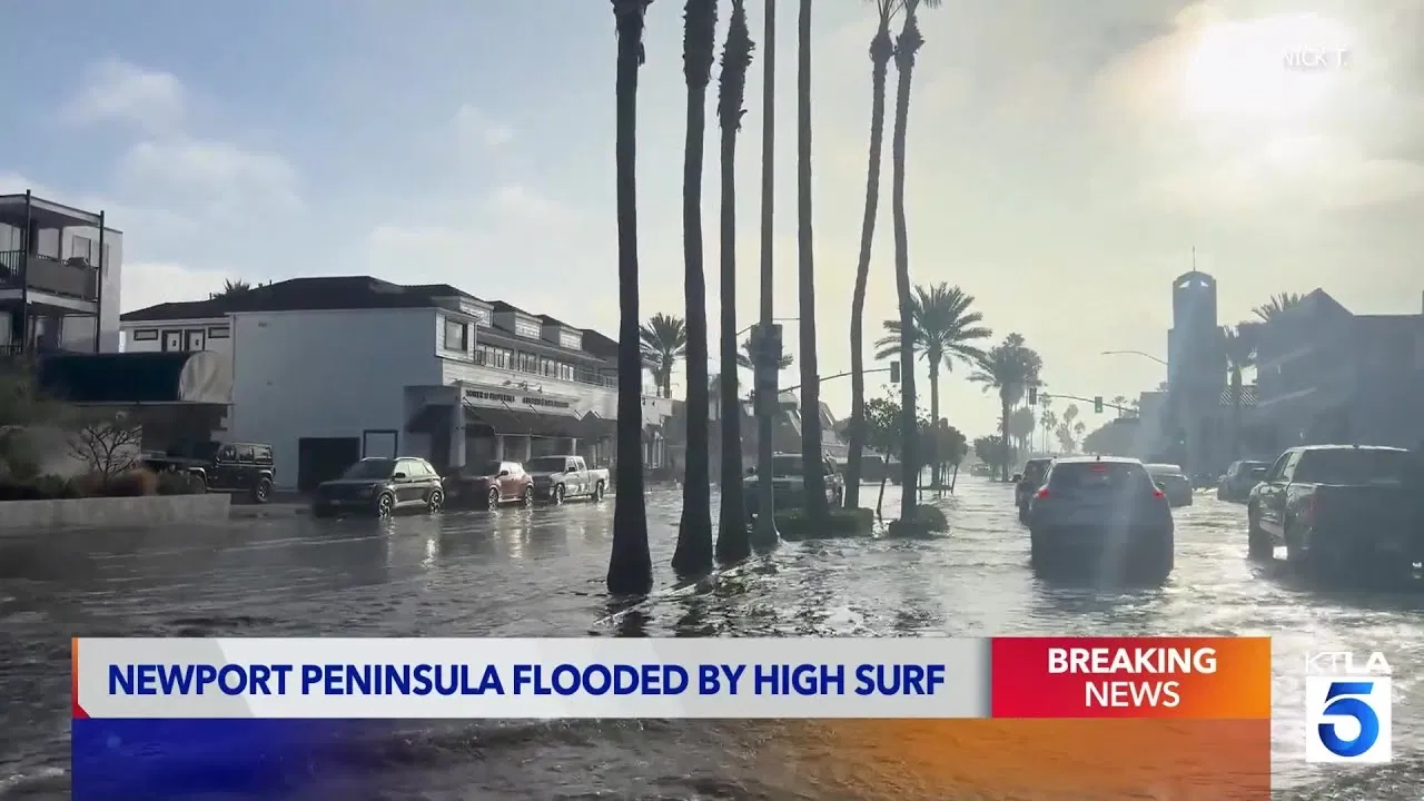
The most damaging element of Rachel was not its wind but its water. Days before the storm's center approached, its winds began pushing ocean water toward the shoreline, stacking up waves and tides along the coast. On Friday, October 9, overnight coastal flooding inundated streets across Newport Beach's low-lying Balboa Peninsula, prompting the city to declare a local emergency.
By early afternoon, officials had closed all beaches and piers in Newport Beach, including The Wedge, the famous surfing spot at the tip of the peninsula, as crews worked to rebuild beach berms and clear sand and debris from flooded roadways. Paddleboarders were even seen floating down neighborhood streets that had turned into temporary waterways.
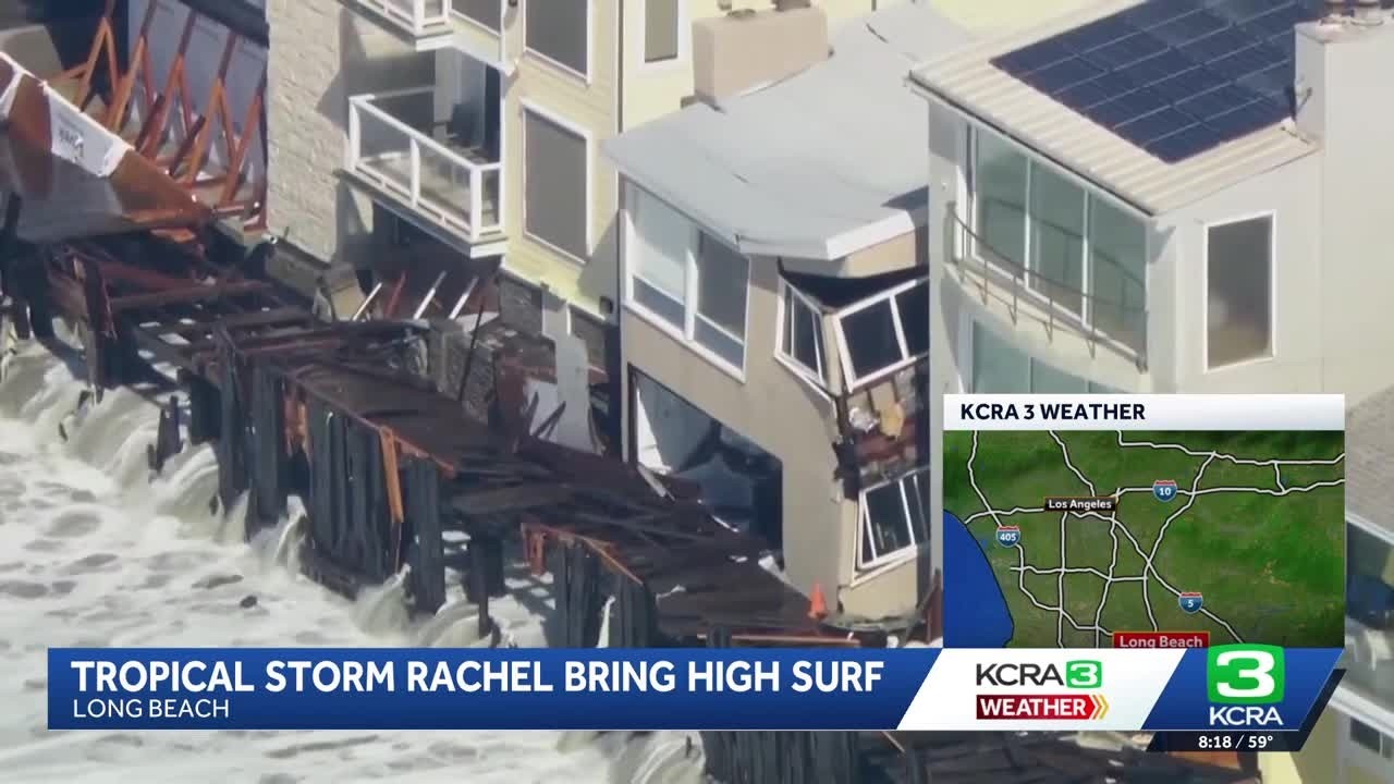
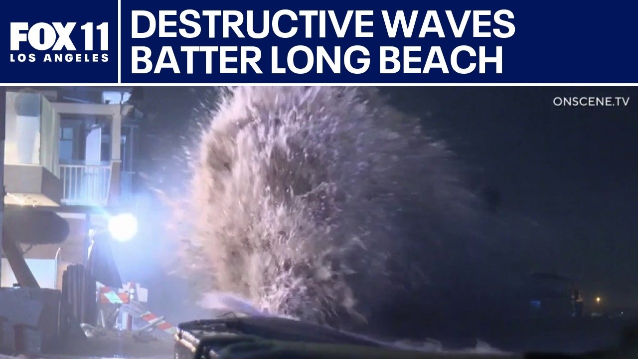
In neighboring Long Beach, the damage was more severe. Powerful waves battered the sea wall along the Long Beach Peninsula, poured into beachfront homes, and smashed through a roughly 30-foot section of the boardwalk. City officials ordered some Peninsula residents to evacuate and reported that at least eight structures had been red-tagged, meaning they were deemed unsafe to occupy. The Los Angeles Times reported that the weather service expected further coastal flooding Sunday, when a high tide at Newport Beach was forecast to reach 7.6 feet at 9:48 a.m.
Forecasters warned that Rachel's post-tropical remnants would spread heavy rain across Southern California and into the Southwest. Some locations were expected to receive 2 to 4 inches of rain, with locally higher amounts, raising the risk of flash flooding in burn-scar areas and urban streets. In a region coming off a long dry stretch, the storm was expected to deliver a soaking that, in some spots, could amount to months' worth of rain in a matter of hours.
Where Things Stand Now
By late Saturday, October 10, Rachel had become a post-tropical cyclone and was forecast to dissipate Sunday over the southwestern United States. Hurricane Simon, a separate storm in the same basin, was simultaneously tracking toward western Mexico, bringing its own threat of coastal flooding to Baja California and the mainland coast near Puerto Vallarta.
For Southern California, the immediate emergency had shifted from preparation to cleanup. Newport Beach and Long Beach crews continued to assess damage to homes, boardwalks, sea walls, and beach berms, while officials monitored additional high-tide cycles for renewed flooding. The rare tropical storm watches served as a reminder that even storms that weaken before landfall can still deliver serious coastal impacts.
What Happens Next
As Rachel's remnants moved inland, forecasters expected the heaviest rain and flash-flood threat to shift toward Arizona, Nevada, and the broader Southwest through the weekend. Coastal communities, meanwhile, were bracing for one more round of elevated surf and high tides before conditions gradually returned to normal.
In the longer term, Rachel underscored a broader pattern scientists have been watching: a very active eastern Pacific hurricane season, with storms increasingly capable of steering moisture and surf toward the U.S. West Coast. While direct hurricane landfalls in California remain rare, the combination of warm ocean waters and favorable steering patterns can push tropical remnants northward, turning far-away storms into local flood threats.
The Bottom Line: What to Remember About Tropical Storm Rachel
- A tropical storm is a rotating storm with sustained winds of 39 to 73 mph, one stage below a hurricane (74 mph or higher).
- Tropical cyclones form over warm ocean water of at least 80°F, powered by rising warm, moist air and organized by Earth's rotation.
- Tropical Storm Rachel formed in the eastern Pacific, briefly became a hurricane, then weakened into a post-tropical cyclone as it approached Baja California and Southern California.
- Rachel's biggest impact was coastal flooding: Newport Beach declared a local emergency, and Long Beach evacuated part of the Peninsula and red-tagged at least eight structures.
- Even a weakened storm can cause serious damage when its surf, tides, and moisture are aimed at the coast.