A nor'easter is a powerful storm that develops along the East Coast of North America, named for the strong northeast winds that sweep across the coastal areas it strikes. As a large-scale extratropical cyclone — a cold-core, low-pressure system — a nor'easter is behind some of the heaviest snowfalls, strongest winds, and most destructive coastal flooding the United States experiences in a given year. While these storms can form at any time, they are most frequent and most violent between September and April, which is why forecasters and residents along the heavily populated I-95 Corridor keep a close watch on the Atlantic every fall and winter.
How a Nor'easter Forms: Cold Air Meets the Warm Gulf Stream
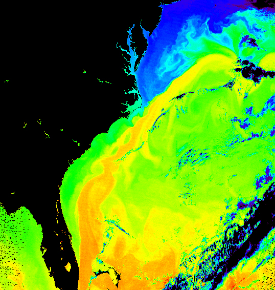
According to the National Weather Service, the U.S. East Coast provides an ideal breeding ground for nor'easters. The process begins with the polar jet stream, which transports cold Arctic air southward across the plains of Canada and the United States, then eastward toward the Atlantic Ocean. At the same time, warm air from the Gulf of America and the Atlantic tries to move northward. The warm waters of the Gulf Stream — typically near 70°F (21°C) even in the middle of winter — keep coastal waters relatively mild, which in turn warms the cold winter air sitting over the water.
This sharp contrast between the warm, moist air over the ocean and the cold, dry air over the land is the fuel that feeds a nor'easter. When very cold, dry air rushes southward and meets the warm Gulf Stream current, low-pressure areas often develop and intensify. In the upper atmosphere, the strong winds of the jet stream remove and replace rising air more rapidly than it can be replaced at lower levels. Combined with the Coriolis force, this helps spin up a strong storm that tracks northeast along the coast — normally from North Carolina toward Long Island, then east toward the waters off Cape Cod.
Meteorologists also classify these storms using the Miller classification, named for J.E. Miller, who created the system in 1946. Type A storms form in the Gulf of Mexico or along the coast of Georgia or South Carolina and bring heavy snow mainly to the inland South, Mid-Atlantic, New England, and Atlantic Canada. Type B storms form from a parent low-pressure system over the Ohio Valley, which then redevelops over the Gulf Stream off North Carolina or Virginia, spreading wintry precipitation from the Great Plains eastward.
Timeline: The Most Destructive Nor'easters in U.S. History
Nor'easters have shaped American weather history, and some remain legendary generations later. Here are the storms that defined the term:
- Great Blizzard of 1888 (March 11–14, 1888) — One of the worst blizzards in U.S. history, dropping 40–50 inches of snow and killing roughly 400 people, mostly in New York.
- Ash Wednesday Storm of 1962 (March 5–9, 1962) — Caused severe tidal flooding and blizzard conditions from the Mid-Atlantic to New England, killing 40 people.
- New England Blizzard of 1978 (February 5–7, 1978) — A catastrophic storm that dropped more than 27 inches of snow in parts of New England and killed about 100 people, many trapped in their cars around Boston.
- 1991 'Perfect Storm' (October 28 – November 2, 1991) — An unusual event in which a tropical and extratropical system interacted, producing severe coastal damage in Massachusetts and killing 13 people.
- 1993 'Storm of the Century' (March 12–15, 1993) — A superstorm that formed in the Gulf of Mexico and affected the entire eastern U.S., causing $6.65 billion in damage and 310 deaths.
The National Weather Service notes that past nor'easters have been responsible for billions of dollars in damage, severe economic and transportation disruption, and in some cases disastrous coastal flooding — with damage from the worst storms exceeding a billion dollars.
Nor'easter vs. Hurricane: What Sets These Storms Apart
People often mistake nor'easters for tropical cyclones such as hurricanes, but the two weather systems are fundamentally different. Nor'easters are cold-core, low-pressure systems, meaning they thrive on the drastic temperature difference between Canadian air and warm Atlantic waters. Hurricanes, by contrast, are warm-core systems that draw their energy purely from warm ocean temperatures.
This distinction matters for forecasting and for the type of damage each storm causes. Nor'easters tend to be larger, slower-moving, and longer-lasting than hurricanes, and they can produce blizzard conditions, coastal erosion, and inland flooding across a much broader area. In rare cases — such as the 1991 Perfect Storm — a small tropical cyclone can even develop inside the warm center of an intense nor'easter if sea surface temperatures are warm enough. Nor'easters can occasionally transition into tropical or subtropical cyclones as well, as happened with Tropical Storm Wanda in October 2021.
When and Where Nor'easters Strike
Nor'easters usually develop in the latitudes between Georgia and New Jersey, within 100 miles east or west of the East Coast. From there, they progress generally northeastward and typically attain maximum intensity near New England and the Maritime Provinces of Canada. They nearly always bring precipitation in the form of heavy rain or snow, along with gale-force winds, rough seas, and occasionally coastal flooding.
The heavily populated region stretching between Washington D.C., Philadelphia, New York, and Boston — the I-95 Corridor — is especially impacted. Because the storm season peaks between September and April, these cities face a recurring risk of disruptive snowfall and coastal flooding each cold season. On occasion, a nor'easter will pull cold air as far south as Virginia or North Carolina, bringing wet snow inland to those areas for a brief time before the storm races northward and reaches its peak intensity off the Canadian coast.
Preparing for a Nor'easter: What to Do Before It Hits
Because a nor'easter can cut power and leave communities in the dark, the National Weather Service recommends preparing well before a storm threatens your hometown. Experts advise keeping at least three days of food, water, and other provisions in a disaster supplies kit, and sitting down with your family to create an emergency communications plan so loved ones know how to stay in touch if separated.
When a nor'easter is imminent, forecasters issue winter storm, blizzard, high wind, and coastal flood watches and warnings to alert the public. Residents should heed local authorities, stay off the roads when advised, and never drive into flood waters. These simple actions can make the difference between riding out a nor'easter safely and facing serious danger.
The Bottom Line: Key Facts About Nor'easters
- A nor'easter is a cold-core extratropical cyclone named for its strong northeast winds.
- It forms when cold Arctic air collides with the warm Gulf Stream, energized by the jet stream and Coriolis force.
- Peak season runs from September through April, with the I-95 Corridor most at risk.
- Nor'easters bring heavy snow or rain, gale-force winds, rough seas, and coastal flooding.
- They differ from hurricanes because they are cold-core systems driven by temperature contrasts, not warm ocean water.
- Preparation — three days of supplies, a family plan, and heeding warnings — is the best defense against these powerful storms.