
When the National Weather Service issues a winter storm watch, it's a critical signal that potentially dangerous weather could be heading your way within the next 48 hours. Unlike a warning that indicates imminent danger, a watch means conditions are favorable for significant winter weather—heavy snow, sleet, or freezing rain—but the exact timing, location, and intensity remain uncertain. Understanding what this alert means, how winter storms actually form, and how to prepare can mean the difference between staying safe and facing dangerous conditions. With winter storms causing over 6,000 deaths and 480,000 injuries annually from weather-related crashes alone, according to National Weather Service data, being informed isn't just educational—it's essential for survival.
The Science of Snow: How Winter Storms Actually Form
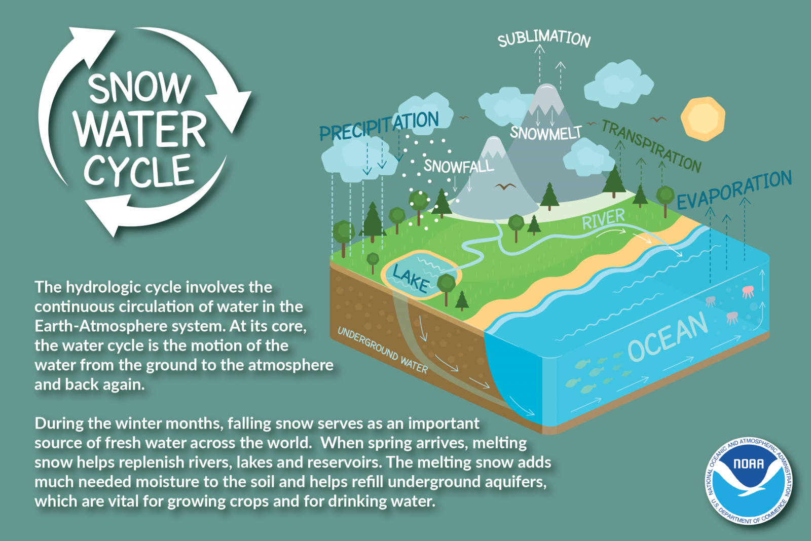
Winter storms, whether they bring gentle snowfall or dangerous blizzards, all begin with the same fundamental meteorological processes. According to the University Corporation for Atmospheric Research (UCAR), winter storms require three key ingredients: moist air rising into the atmosphere, a source of moisture, and cold air at both cloud level and near the ground. The classic winter storm scenario involves the collision of two contrasting air masses—cold, dry air from Canada moving southward and warm, moist air flowing northward from the Gulf of Mexico. Where these air masses meet, called a front, the warmer air is forced upward over the denser cold air. As this moist air rises, it cools and condenses, forming clouds and precipitation. If the temperature remains below freezing from the cloud to the ground, the precipitation falls as snow. However, if there are layers of above-freezing air at different altitudes, the precipitation may melt and refreeze, creating sleet or freezing rain. This delicate temperature balance explains why winter weather forecasts can be so challenging and why precipitation types can change rapidly over short distances.
The intensity of a winter storm depends on the strength of the temperature contrast between the air masses and the amount of available moisture. Stronger contrasts create more vigorous lifting, leading to heavier precipitation, while abundant moisture from sources like the Great Lakes or Atlantic Ocean can fuel massive snowfalls. Lake-effect snowstorms, for example, occur when cold air passes over relatively warm lake waters, picking up moisture that then falls as heavy snow on downwind shores. Nor'easters—powerful coastal storms that impact the Eastern Seaboard—draw their energy from both the temperature contrast between land and ocean and the abundant moisture of the Atlantic.
Watch vs Warning: Decoding the National Weather Service's Alert System
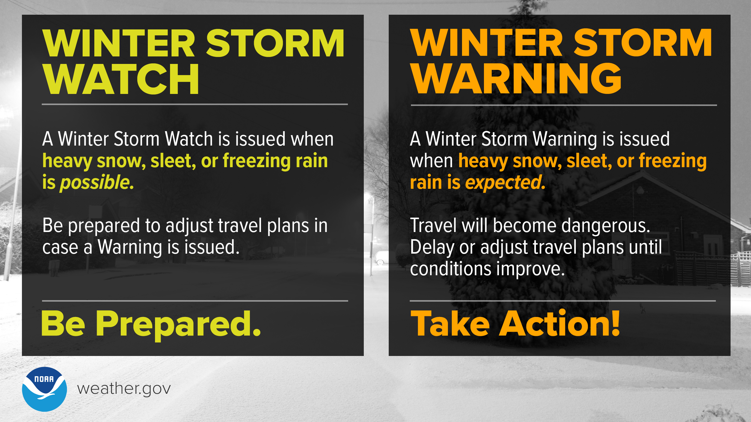
When severe winter weather threatens, the National Weather Service (NWS) issues a tiered system of alerts to help the public understand the level of danger and take appropriate action. Understanding the difference between these alerts is crucial for making safe decisions. As defined by the NWS Baltimore/Washington office, a Winter Storm Watch is issued "when there is the potential for significant and hazardous winter weather within 48 hours." This means conditions are favorable for dangerous winter weather—but its occurrence, location, and timing remain uncertain. A watch is essentially a heads-up to start preparing, as there's at least a 50% chance of severe conditions developing.
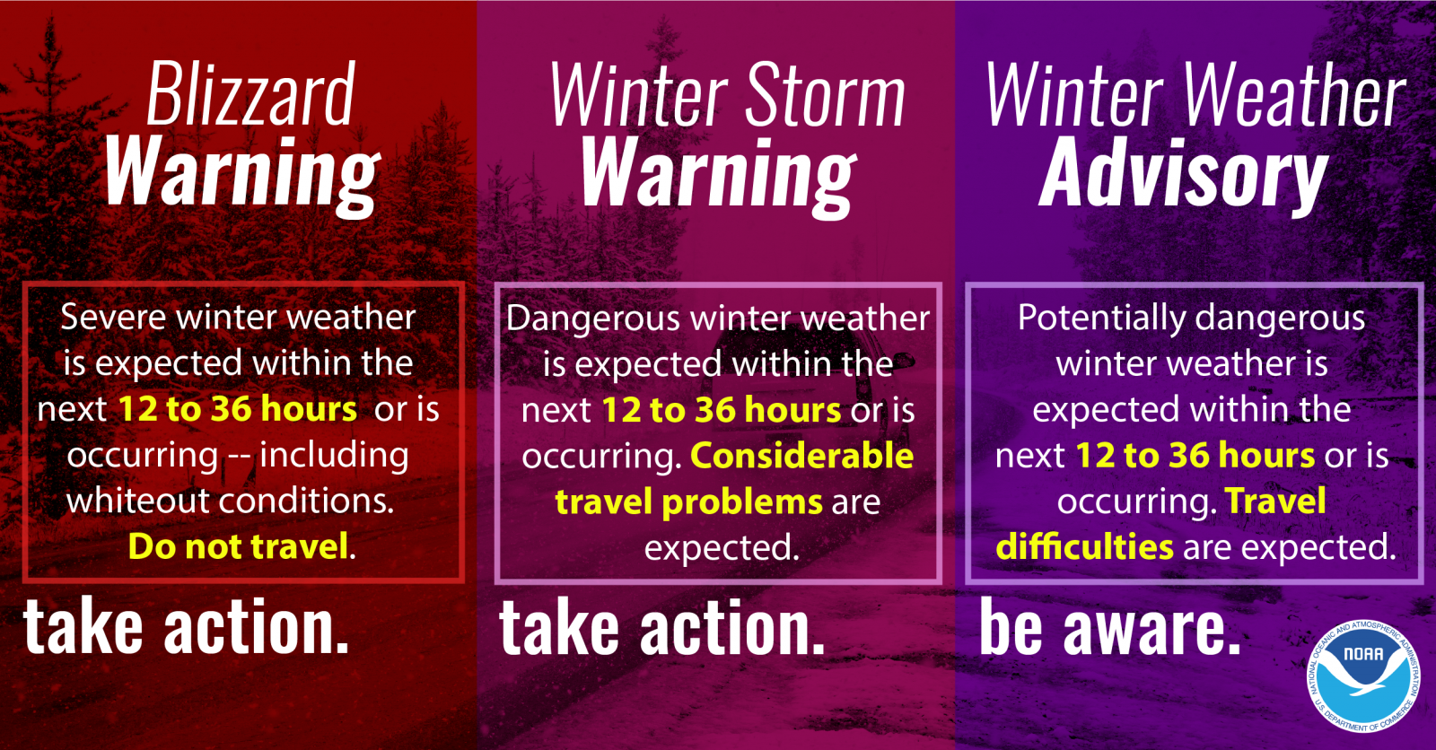
When confidence increases to 80% or greater probability, and the event becomes imminent, the NWS upgrades to either a Winter Storm Warning or a Winter Weather Advisory. According to NWS Central Illinois, "A Warning indicates that conditions pose a threat to life or property, and that travel will become difficult or impossible." This means hazardous winter weather is either occurring or will begin shortly—typically within 12 to 24 hours. Heavy snow (at least 6 inches in 12 hours or 8 inches in 24 hours in central Illinois), significant ice accumulation (¼ inch or more), or a dangerous combination of snow/ice and wind triggers this highest-level alert.
A Winter Weather Advisory indicates less severe but still hazardous conditions that "pose a significant inconvenience, and if caution is not exercised, could lead to situations that may threaten life and/or property." This might include 2-4 inches of snow, light ice accumulation, or blowing snow. While not as dire as a warning, an advisory still requires caution, especially during travel.
Snow, Sleet, or Freezing Rain? Understanding Winter Precipitation Types
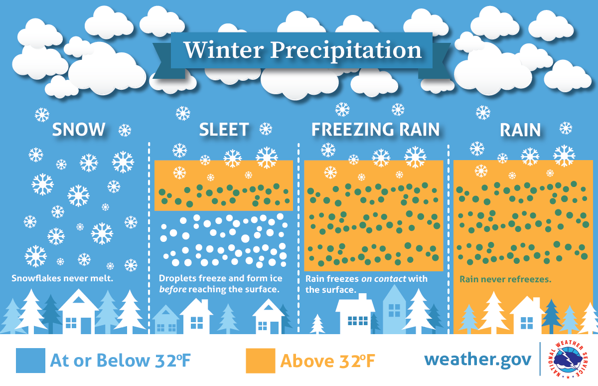
The type of winter precipitation that reaches the ground depends entirely on the temperature profile of the atmosphere through which it falls. As explained by Weather Wiz Kids, snow forms when water vapor changes directly to ice (deposition) high in the atmosphere and remains frozen all the way to the surface. Each snowflake is a unique six-sided crystal that can contain up to 200 individual ice crystals. Sleet, often called ice pellets, begins as snow that melts into rain droplets as it falls through a shallow layer of warm air, then refreezes into solid ice pellets before reaching the ground. Sleet typically bounces when it hits surfaces and doesn't stick to objects as much as freezing rain.
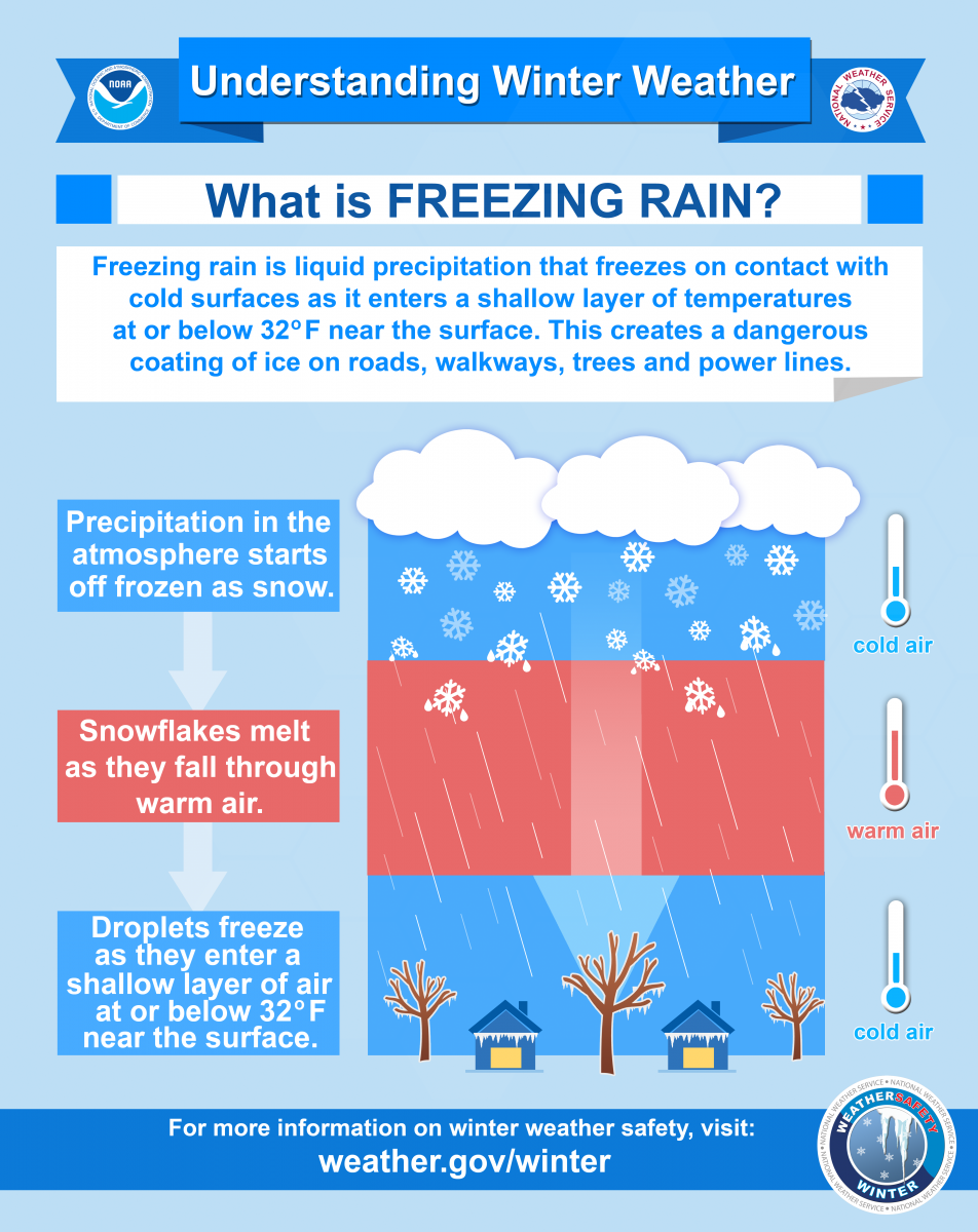
Freezing rain is perhaps the most dangerous winter precipitation type. It starts as snow, melts completely into rain in a deep warm layer, then falls through a shallow layer of freezing air near the surface. The raindrops become supercooled (remaining liquid despite being below freezing) and freeze instantly upon contact with cold surfaces like roads, trees, and power lines. Even a thin glaze of ice—as little as ¼ inch—can make travel treacherous and cause tree branches and power lines to snap under the weight. The National Weather Service issues Ice Storm Warnings when ice accumulation of ¼ inch or more is expected.
Predicting the Unpredictable: How Meteorologists Forecast Winter Storms
Modern winter weather forecasting combines advanced technology, computer modeling, and meteorological expertise to predict storms with increasing accuracy. Meteorologists analyze data from weather satellites, radar, weather balloons, and surface stations to create three-dimensional pictures of the atmosphere. Computer models then simulate how these conditions will evolve, but winter storms present particular challenges because small changes in temperature—just a degree or two—can determine whether a location receives snow, sleet, rain, or freezing rain.
The National Weather Service emphasizes that "winter forecasts can change frequently" and advises the public to "focus more on the winter storm's impacts" rather than exact snow totals. Forecasters use ensemble modeling—running multiple simulations with slightly different starting conditions—to gauge confidence and show possible ranges of outcomes. This approach helps communicate uncertainty and prevents over-reliance on single "perfect" forecasts that might be wrong.
One key forecasting challenge is the "rain-snow line"—the boundary where precipitation changes from snow to rain. This line can shift miles based on subtle atmospheric changes, dramatically affecting accumulation. Meteorologists also monitor indices like the North Atlantic Oscillation and Arctic Oscillation, which influence large-scale patterns that favor or suppress winter storms in certain regions.
Winter Ready: Your Essential Preparation Checklist When a Watch is Issued
When a Winter Storm Watch is issued, you typically have 24-48 hours to prepare before conditions potentially deteriorate. The American Red Cross and National Weather Service recommend these essential steps:
Home Preparation:
- Insulate pipes and allow faucets to drip during extreme cold to prevent bursting.
- Ensure you have adequate heating fuel and alternative heat sources (safely operated).
- Install weather stripping, caulk windows, and use insulation to keep warm air in.
- Test smoke and carbon monoxide detectors—these are critical when using space heaters or fireplaces.
- Gather emergency supplies: at least three days of non-perishable food, water (one gallon per person per day), medications, flashlights with extra batteries, battery-powered radio, and first-aid kit.
Vehicle Preparedness:
- Keep your gas tank at least half full to prevent fuel line freezing.
- Prepare a winter car kit including blankets, jumper cables, sand or cat litter for traction, shovel, ice scraper, flashlight, and high-calorie snacks.
- Check your battery, tires, wipers, and antifreeze levels before winter arrives.
Personal Safety:
- Plan to stay indoors during the storm. If you must go outside, dress in layers—wet clothing loses insulation value.
- Recognize signs of hypothermia (confusion, shivering, slurred speech) and frostbite (numbness, white or grayish-yellow skin).
- Avoid overexertion when shoveling snow, which triggers heart attacks—the leading cause of winter storm deaths.
Communication Plan:
- Designate an out-of-town contact everyone can check in with.
- Keep mobile devices charged and have backup power sources.
- Sign up for local emergency alerts and monitor NOAA Weather Radio.
Key Takeaways: Staying Safe During Winter's Wrath
Winter storms demand respect and preparation. Remember these essential points:
- Understand the alerts: A Watch means prepare; a Warning means take action; an Advisory means be cautious.
- Respect all winter precipitation: Even small amounts of ice or snow can create hazardous conditions, especially on roads and bridges.
- Preparation is proportional to safety: The time you spend preparing before a storm directly impacts your safety during it.
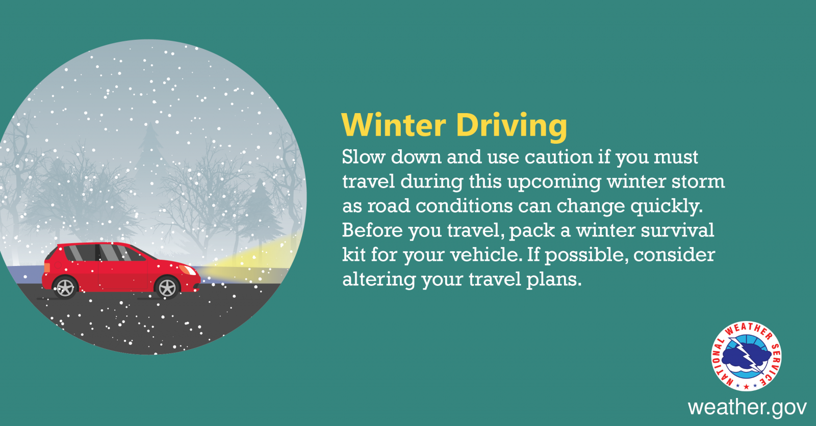
- Avoid unnecessary travel: Most winter storm injuries and fatalities occur on roads. If you must drive, slow down and increase following distance dramatically.
- Check on vulnerable neighbors: Older adults, those with medical conditions, and people living alone may need assistance before, during, and after storms.
By understanding how winter storms form, what the alerts mean, and how to prepare, you transform from a passive observer to an active participant in your own safety. Winter's beauty can quickly turn dangerous, but knowledge and preparation provide the best defense against nature's frozen fury.